


Manipur border issue : A work of unskilled professionals
R.K. Shivachandra *
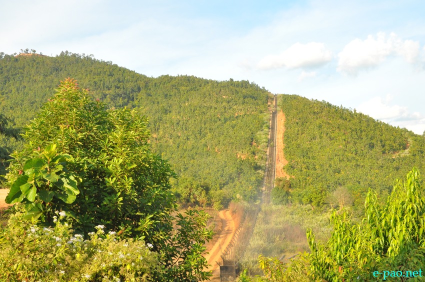
The fencing along Indo-Myanmar border as on December 7 2013 :: Pix - Deepak Oinam
Manipur before the advent of the British had been a story of struggle vying for supremacy between the people of Burma known to the Manipuris as Awa after the Ava dynasty that ruled Burma from Mandalay in upper Burma. In the fluctuating fortune between the two sides, the Burmese had shown the might and thrusting power of the famed Manipuri Cavalry who, armed with the deadly Arambais, forced the Burmese to retreat.
When the Burmese took their revenge and occupied Manipur they returned home with members of these famed horsemen and they formed the advance thrust when king Alungopaya attacked Thailand in Chiangmai. The British, eager to save their interest from growing French influence in the Bay of Bengal, saw an ally in Manipur. Thus was born the Manipur Levy under charge of Maharaj Gambhir Singh, which drove the Burmese away. This is the beginning of the history between Manipuris and Awas some centuries ago.
But this is the story that gone by and today the hospitable Myanmarese receives us with glittering white teeth across the border cladding in their finest lungi. Time the best healer and now we are good friends rest are just history.
Border issue exists everywhere wherever there are two nations. A border is a line demarcated with a mutually accepted nod between the two neighbourly nations thereby draws the boundary. In the case of Manipur and Myanmar, border is demarcated by the nature, sometimes it is measured from a middle of river or by the foothills. There had not been a single dispute so far till the infamous border fencing begun in 2013 by the Indian Government. The sprawling green plains happen to be unclaimed field by either of the side and thus this could be called the land of God earlier.
A father left a sprawling homestead for his sons. His sons built houses in it and thus vast land belonged to all his off springs till one among the siblings start earmarking his own land and fencing began on that. The border issue in India Myanmar border in Manipur is the work of some unskilled professionals who by themselves called strategists.
India Myanmar shares 1600 kms border. A long distance indeed. The 10 Kms. border fencing which was stopped halfway was designed by some policy makers to stop the drug smugglings, gun runners and most importantly to hamper the underground rebel movements in this border.
How could this happen? Will this peanut 10 Kms stretch border fence stop all these menace? This could happen only in the diaries of those bureaucrats and some fungus moustached musketeers who could penetrate their eyes on the kick bag of crispy Indian denominations suppose to be swindled from this untrodden valley in the name of fencing.
I simply defy it in the capacity of a denizen of India. The policymakers in Delhi slept over their big volumes of the India-Myanmar border and as a result of it the border issue gain momentum bit by bit. It is said that there are 46 battalions of Assam Rifles in Manipur out of which 16 battalions were engaged in guarding the border that it never happened. They are only busy with their counter insurgency strategies and guarding the last wall of India failed to sneak into their minds as a result border pillars moves here and there like a ghost .
We have never seen them patrolling in the interior border sectors. As a rule the Assam rifles who are the custodian of border should keep intact the border pillars. They are supposed to feed report to the district administration on weekly basis about the development on the border. This never happen.
I doubt whether our deputy commissioners understand that such rule exists. The fencing erected on the middle of the hillock at Gopijang contradicts all the international and local border fencing norms and easily presumable that the fencing was erected on the convenience of those who got a lucrative 'work order' to execute the fencing job. They call it security fencing.
India fails to recognise that the border issue between Myanmar and India should be dealt with the same yardstick as they deal in Indo-Bangladesh border, Indo-Pakistan Border and yes the same eagle eye that they scanned on the China Arunachal border should imply but unfortunately the awaited eagle dares to fly over this region. Why this sense fails to come in the big head of those policy makers who breathe the fresh air in Delhi.
Am I anti-national writing this piece? Definitely not. Recently American based Google had made certain errors while uploading the border map particularly on India Myanmar border. The more than two thousand years old border town "Moreh" of India's State Manipur had now dotted in Myanmar territory in the Google map. Moreh had been one of the oldest towns that stood the test of the time in Manipur border of Indian soil for centuries now.
Earlier Google came under fire from Indian Government for uploading parts of Arunachal Pradesh in China's map. Google had to eventually rectify/apology the mistake they had committed. India was so restless and anxiety loomed heavy when Google uploaded this controversial map in the satellite. There was a big hues and cries in the media sections of the mainland but why it is not happening here. I, as a humble citizen asked the same question to the Honourable Prime Minister of India when I met him last.
Government of India fails to use the same yardstick of wisdom in the case of India Myanmar border in Manipur. We need to redress the disgruntled general public and hence, it is ardently appealed that the good Office of Prime Minister of India immediately intervene the ploy of Google that they stop playing 'off and on' tactics in India's boundary map. Government of India is duty bound in the larger interest of millions of the Indian citizens to give a stern warning to the Google so that they rectify it with an apology explaining their condition that Google wouldn't repeat it again in future.
The border issue will continue but nothing that the people living in both sides supposed to be in a loggers head because of the dispute. Let two governments sort it out. Let us take the example of Prea Vihear Temple in Thailand Cambodia border, the temple which stood tall atop a the Dangrek Mountain scanned about 525 metres.
For years the side is the bone of contention between the two nations. The two governments entered into several round of dialogues sometimes the armies of both the nations swamped over the border in their own position but public is not part of it. If somebody tries to drag public in such game they are inefficient governments.
|

The writer is President, Indo Myanmar Fraternal Alliance
He can be contacted at nongpokharam(at)gmail(dot)com
This article was posted on December 27, 2013 .
* Comments posted by users in this discussion thread and other parts of this site are opinions of the individuals posting them (whose user ID is displayed alongside) and not the views of e-pao.net. We strongly recommend that users exercise responsibility, sensitivity and caution over language while writing your opinions which will be seen and read by other users. Please read a complete Guideline on using comments on this website.


