1. INTRODUCTION
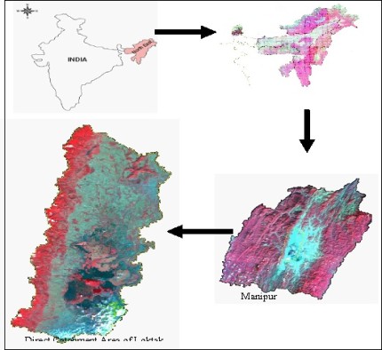
Manipur, the eastern most state of India lying 92 o 59'E to 94o45'E longitude and 23o50'N to 25o41'N latitude, straddling the international border between India and Myanmar, has a peculiar situation in the eastern Himalayas and watershed area of the great river basin systems the Brahmaputra and the Irrawady.
It is blessed with an enormously rich heritage of wetlands. Topographically it is surrounded by seven ranges of hills and the valley lies in between. Therefore, wetlands, in Manipur are mostly found in the valley area and are known by the generic name Pat (pronounced as paat).The surrounding hill districts are also replete with many kinds of wetlands, great and small [Wetlands of Manipur, Vol-I- 1999].
The pats of Manipur are known to have their own life-span and hydrologic characteristics related to the evolving geo-physical character of land itself. In the beginning of the 20th century there were nearly 500 pats in the Manipur Valley, covering a large position of its area.
Loktak lake after acclaiming Ramsar site is well known internationally but apart from Loktak other well-known pats of Manipur are Ikop pat, Pumlen pat, Waithou pat, Ngakra pat and Loushi pat.
Loktak lake is the largest freshwater wetland in North-eastern region of India and is situated between 240 25' to 24042' N latitudes and 930 46' to 93055'E longitudes. This lake was designated as wetland of International Importance under Ramsar Convention in 1990 because of its biological richness where naturally occurring phumdis (floating vegetation) covers the lake extensively and is a specialized habitat for many biotas besides being useful to the local people in many ways.
The Keibul Lamjao National Park in the southern part of the lake is also a unique floating wildlife reserve and the natural home of the endangered Manipur brow antlered deer, Sangai. Deforestation and shifting cultivation in the catchment has accelerated the process of soil erosion resulting in the lake shrinkage.
The nutrients from catchment area and domestic sewage from Imphal city carried by Nambul River are discharged into the lake which is another major problem of the lake [LRIS Report, 2003]. All these activities have direct bearing on ecological stability of the lake.
2. STUDY AREA.
Loktak has direct catchment of 1040 sq. km and falls under the sub-basin of the Manipur River. The catchment area lies between 24o24'to 24o57' N latitude to 93o40' to 93o58'E longitude. The topography is undulating having elevation of 780 m at the foothills adjoining the central valley and about 2068 m at highest peak. There are about 98 villages with a total population of 21,334 [1991 census].
 |
| Fig. 2.1 Location Map of Loktak Catchment Area |
|
The presence of Ithai Barrage, a multipurpose project for generation of hydel- power and irrigation which was commission in 1983 at Ithai at the southern nearest tip of Loktak, has brought about drastic hydrological changes.
Loktak catchment area comprises the elongated hilly terrain of various altitudes along with isolated hillocks, plains and marshy lands. Altitude of elongated hill ranges and isolated hillocks varies between 820 to 2068 meter and 760 to 1100 meter above mean sea level respectively.
The rock formations in the catchment area are cretaceous limestone, the Disang with Serpentinites (Lower to Middle Eocene-Upper cretaceous), the Sumas and the Thipams (Miocene). Surma group occurs in the lower reaches of hills where as the Disang and Thipam groups occur in high reaches of hills.
Disang formation comprises grey sandstone-grit-conglomerate limestone sequences intruded by serpentinites containing minor amounts of enstalite, chromite, amphiboles and magnetite. The Surma and Thipam groups represented by argillaceous and arneceous sequence respectively.
To be continued...
* Rajkumari Sunita Devi is from Manipur Remote Sensing Applications Centre,
Pradeep Srivastava is from Deptt. of Limnology, Bharkhatullah University, Bhopal and
Asha Gupta is from Dept. of Life Sciences, Manipur University.
This Scientific Paper was webcasted on 9th December 2007.
|


