


Report of the Expert Team On landslide affected areas in Manipur
- Part 2 -
Prof Arun Kumar *
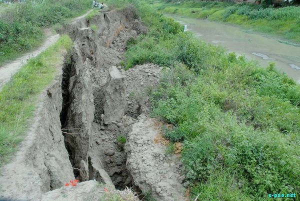
Landslide at Imphal River near Khuman Lampak :: July 01 2009
Broad morphology of the slide
The mapping of the landslide was made at the spot during the visit and the Crown height is 60 mts with the length of 250 mts on the highway with a scarp width of 10 mts. Depth of slide was 160 mts.
Mitigation Measures:
Necessary mitigation measure will be brought and the conclusion of the rapid study. However, for the permanent remedial measures a 20 kms stretch along the NH02 highways needs to be studied under networking mode and involving all types of geological, structural, geophysical, geochemical, hydrological and hydro-meterological, and geotechnical kinametrics and factor of safety.
Finally, all these outcomes has to be brought on the GIS platform including hazard zonation mapping caisitive factors triggering factors allowable slope cut and factor of safety based polygonisitaion entire stretch. It will also suggest the sites for monitoring.
Relevance to the proposed Rapid study:
This will be a model studies for entire NE India and various PIs who are involved in the projects as will gain better training and knowledge base. They will prepare similar maps for mitigating the landslide in the entire NE Region.
4. Regional Tectonics pattern
Manipur falls under the Indo Burmese Arc (IBA), which is broadly N-S trending arcuate fold-thrust belt, located between the Bengal Basin in the west and Central Burmese Basin in east. The Bengal basin joins with Tertiary shelf of Assam to the north. Southward it continues as Bengal Fan. IBA provides evidence of strong orogenic deformation that is the characteristics of Cenozoic fold mountain belt in context of Himalayan Terrain.
The 1200 km long IBA, trending NE-SW NNW-SSE, has been subdivided into three segments each of about 400 km in length from south to north, as Arakan Yoma and Chin Hills in Burma and Naga Manipur hills in India. IBA is 250-700 km wide is a Tertiary orogenic belt forms a broad convex arc towards Indian foreland. It has unique S shape which abuts in south of Eastern Himalayan Syntaxes (EHS), which is further forms the buttress for E-W trending Himalayan Orogenic Mountain Belt (Fig 3).
The India-Burma plate boundary is a convergent plate boundary where the Indian plate had subducted eastward below the Burma micro-plate between the Early Cretaceous and Early Palaeogene. It is comprised of accretionary wedge sediments and ophiolite along the Naga Hills-Chin Hills-ArakanYoma Hills segment of the Indo-Burma Ranges (IBR), and the Andaman-Nicobar (A&N) Islands.
The Naga-Manipur Ranges are offset northward by the Sagaing Fault, a major N-S, dextral strike slip fault along the boundary between the Burma micro-plate and the Asian plate. The region is seismically very active and the seat for the two great earthquakes in the last 100 yrs (Shillong Earthquake 8.7 M 1897 and Arunachal China Earthquake 8.7 M of 1950). Further, this area is seismically active and included in zone V.
5. Rainfall & Climate
The climate is salubrious with winter cold and summer warm. The average rainfall of the district is about 2000 mm. There are about nine rainy months. Most of the rainfall is received in the month of July to August with occasional rain from September to October. Winter is very cold with minimum temperature falling down to 2-3°C. December and January are the coldest months of the year. Summer is moderately warm with maximum temperature recorded at 29 - 32°C.
6. Geomorphology & Soil Type
Geomorphologically, the region around slides can be categorised under the following hills:
a. Low to Moderate Hills Low lying dissected, sub-parallel hills aligned in NE-SW with limited valley formation are found to occur in the western part of the district. Rock types constitutes of sandstone, siltstone, shale and mudstone.
b. Moderate Structural Hills Moderately high linear structural hills with narrow valleys occupy north central part of the district. Hills constitute of semi-consolidated sandstone, siltstone, shale and claystone and show high degree of erosion.
c. Denudo-Structural Hills Linear, curvilinear and irregular shaped denuded hills associated with small valleys are found to occupy south-central part of the district. These are predominantly composed of semi-consolidated sandstone, shale with lesser degree of erosion.
d. High Structural Hills Long linear parallel to sub-parallel rigid hills occupy central and south-western part of the district. These comprise hard and compact sandstone, shale, siltstone mainly having low erosional activity.
7. Recommendations
1. Large scale topographic mapping 1: 500 scale with one meter contour interval with laser techniques and preparation of a detailed lithological and tectonic map
2. Slope map from large scale contour maps derived from the laser techniques
3. Detailed measurement of filed features for RMR and SMR analysis
4. Geophysical profiling along and across the slides to bring out the sub surface geology
5. Mapping of spring with discharge including the location of submergence and emanations on down slope
6. Kinematics studies for wedge failure and clay mineralogy
7. Mapping of possible slip surface and Evaluation of factor safety
8. Mitigation measures
9. Expert committee unanimously decided to undertake a Rapid study of landslides for providing mitigations measures to Boarder Road Organisation as requested by them at Landslides sites.
Concluded ..
* Prof Arun Kumar wrote this article for The Sangai Express
This article was posted on October 5, 2015.
* Comments posted by users in this discussion thread and other parts of this site are opinions of the individuals posting them (whose user ID is displayed alongside) and not the views of e-pao.net. We strongly recommend that users exercise responsibility, sensitivity and caution over language while writing your opinions which will be seen and read by other users. Please read a complete Guideline on using comments on this website.


