
TODAY -


| Catchments characterization of Loktak Lake - Using Remote Sensing & GIS - - Part 2 - |
|||||||||||||||||||||||||||||||||||||||||||||||||||||||||||||||||||||||||||||||||||||||||||||||||||||||||||||||||||||
Rajkumari Sunita, Pradeep Srivastava, Asha Gupta * |
|||||||||||||||||||||||||||||||||||||||||||||||||||||||||||||||||||||||||||||||||||||||||||||||||||||||||||||||||||||
3. OBJECTIVES
The database of this catchment study consists of primary, secondary and integrated database of spatial and non-spatial data on different components of the catchment. Census data of 1991 & 2001 is used for socio-economic studies of the hill and valley region. Table 4.1 gives the list of satellite data use. Table 4.1 Data Source
5. METHODOLOGY / THEMATIC MAPS: Visual and digital image interpretation techniques were used to prepared thematic maps on 1:50,000 for 1990, 1995, 2000 using 23.5 meter resolution data of IRS-1C, 1D and 1:25,000 for 2004 -05 using high resolution data like IKONOS , for some area and merge data of 2.5 meter resolution using LISS-III and PAN data . Secondary data for socio-economic etc are also incorporated. The thematic maps are :
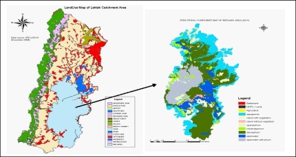
Information on Land use/cover pattern, especially the extent and spatial distribution is a pre-requisite to derive information on temporal changes. The land use /cover information helps to identify areas where immediate attention has to be taken for reviving various landscape elements. The present status of land use (Table 5.1) in the catchment is useful for identifying locations for taking up soil conservation measures by involving village communities, for minimizing land degradation. Land use classification for 2004-05 is base on guideline of 'Biodiversity Conservation in Wetland Project' by Space Applications Centre, ISRO, Ahmedabad. Table 5.1 Land use- catchment area 2004
The land use class of wetland is further classified by preparing a structural components map of Loktak wetland area which shows various classes of phums, agriculture land, islands, aquaponds etc. In the present study SOI topography map of 1970 was use as a base to delineate water spread and demarcate wetland boundary. IKONOS data was use for preparation of the structural component map of 2004-05 (Table 5.2). Table 5.2. Structural components of wetland area 2004
To be continued... * Rajkumari Sunita Devi is from Manipur Remote Sensing Applications Centre, Pradeep Srivastava is from Deptt. of Limnology, Bharkhatullah University, Bhopal and Asha Gupta is from Dept. of Life Sciences, Manipur University. This Scientific Paper was webcasted on 14th December 2007. |
* Comments posted by users in this discussion thread and other parts of this site are opinions of the individuals posting them (whose user ID is displayed alongside) and not the views of e-pao.net. We strongly recommend that users exercise responsibility, sensitivity and caution over language while writing your opinions which will be seen and read by other users. Please read a complete Guideline on using comments on this website.


LATEST IN E-PAO.NET
Jump Start
DBS Imphal SubSite |
Readers Mail |
Editorials |
Education Announcements |
Essay |
Exclusive Event |
Flash - Audio Visual |
Incidents |
LFS Imphal SubSite |
News Timeline |
Poetry |
Opinion |
Sports |
Rock Concert |
RSS |
Top Stories |
Wathi Jugai